
As an example for real geomonitoring with MONIKA, the deformation analysis software has been applied to the real GNSS observation data (RINEX) from the Eifel-Plume-Project.
The centre of the Eifel-Plume area is the German town of Daun (see fig.), and the whole area is under the influence of a so called "mantle plume". This is characterise by an upwelling of the earth crust due to ascending magma from the Earth's mantle, a pre-stage of volcano activity. Earlier terrestrial levelling measurements already showed that uplift of the earth surface in the Eifel-Plume area (about 1-2 mm/a).
To monitor the above mentioned uplift permanently the stations of German GNSS positioning service SAPOS in the countries of Rheinland-Pfalz and Nordrhein-Westfalen, as well as Belgium GNSS-stations, are used as a Geo-Sensor-Network for the monitoring of the geodynamic active region Eifel-Plume in the western part of Germany.
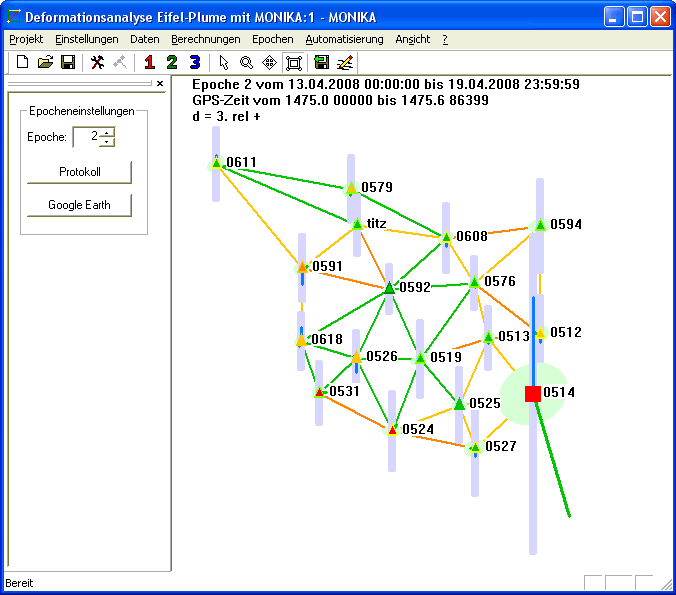
Eifel-Plume-GNSS-network and a screenshot from the MONIKA software of this network, click to enlarge
Up to now the GNSS RINEX-data of the single epochs has been processed with the software WaSoftNet and the further processing, namely the analysis of single point movements, was done via Helmert-Transformations between each two subsequent epochs.
Due to GNSS antenna changes in the SAPOS-stations, the number of identical points in each two epochs however decreased, so that the above displacement analysis concept got more and more weak.
MONIKA is able to handle and model unavoidable antenna changes , which affect the configuration of the reference points, due to the concept of a multivariate and multi-epoch deformation analysis approach. So MONIKA software was applied in to the Eifel Plume GNSS data. Based on the daily observations in the RINEX-file format, the baselines for each day are processed in MONIKA with the module BEPEC_PRO, which is common to MONIKA and GOCA, using there the software WA1. The automatic setting up the epochs in MONIKA was due to weekly epochs, using all included baselines in the strict 3D adjustment of MONIKA. Four epochs with an inter-epoch distance of 6 months in total time-span of 1 ˝ years - from 14-October-007 to 18-April-2009 - were processed.
The antennae changes were successfully detected by MONIKA in the frame of the automated statistical testing, and the amount of the displacements of the antenna changes was each estimated properly. In the above time span the estimated uplift of about 2 mm could not be detected, due to the general sensitivity of the high component of about 10 mm. And additionally there was also an antenna change in the observed station in Daun.
Eifel-Plume 2009 (0.3 MB)
(for this solution you will need at last the MONIKA-Demo version 2.54)